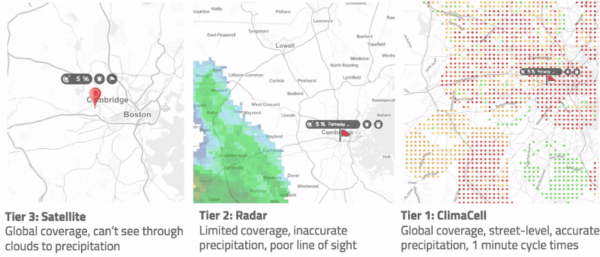
For This Week in Weather, we’ll be sharing the big weather stories and the impact in the US for the coming week of May 11, 2020 and how it will impact your business. So on that note, let’s get to it!
Wednesday (5/13)
A weather system strengthening over the Central and Southern Plains will be capable of areas of strong to severe thunderstorms from northern Texas northward to Nebraska and Iowa. There may be isolated tornado development, however for many of these areas, strong to severe winds and large hail will be the primary concerns. Initial concerns during afternoon and evening focus from North Texas, Oklahma, and into Kansas; then heading through late evening into overnight, storms focus on northern Kansas, southeast Nebraska, and through Iowa.
Business impact: Energy companies should keep a close eye on expensive equipment in case of hail or tornado damage.
Thursday (5/14)
Morning thunderstorms look possible from eastern Kansas northeastward through northern Missouri, southern and eastern Iowa, and potentially northern Illinois and southern Wisconsin. Some strong storms featuring hail and heavy rainfall as primary hazards, look possible across eastern Kansas and northern Missouri, in particular. Heading into afternoon, additional thunderstorms develop farther south, from southwestern Missouri and southeastern Kansas, southward through eastern Oklahoma and eastern Texas. Tornadoes, strong to severe winds, and large hail, all appear possible from these storms, during the afternoon and evening hours.
Business impact: Any companies with drone operations should reevaluate flights due to high winds and hail.
Friday (5/15)
A new weather system, also developing over the Southern and Central Plains, will be capable of numerous areas of thunderstorms from Texas northward to the Kansas/Nebraska border, then eastward towards the Ohio Valley. Meanwhile, noticeably warmer temperatures overspread the eastern U.S. with temperatures trending to 5°F-15°F warmer than normal for this time of the year.
Business impact: Electric vehicles will perform differently with higher than usual temperatures across the US.