It can happen in a flash.
From damp roads to puddles and ponding to rapidly rising water that carries vehicles away, inundates buildings and basements, destroys crops, breaks bridges, and tragically drowns people and animals.
The atmospheric setup varies from one flood to the next, but the result is always the same: Too much rain in too little time.
A new study in the journal Nature finds that the global population exposed to floods has significantly increased in recent years.
“Flooding is a pervasive natural hazard, with new research demonstrating that more than one in five people around the world live in areas directly exposed to 1-in-100 year flood risk. Exposure to such flood risk is particularly concentrated amongst lower-income households worldwide.”
Tens of millions of people around the world are displaced from their homes each year due to flooding disasters, while damages from flood events run into the hundreds of billions of U.S. dollars in direct asset losses annually. These disasters contribute to the billion-dollar weather events we are seeing every year.
The effects on communities around the world can be devastating. Still, in order to combat the impact of flooding and mitigate unforeseen disasters, we need to understand what conditions lead to flooding and what tools exist to help us reduce these risks.
Understanding Flooding and Flood Forecasting: What Atmospheric Conditions Lead to Floods?
Extreme floods are increasing in frequency and intensity worldwide.
But why? To understand, we must understand what conditions lead to floods.
Flooding Conditions
A combination of the following causes flooding:
- Prolonged Rainfall: Continuous rain over several days saturates the soil, causing rivers and lakes to overflow
- Rapid Snowmelt: Sudden warming can cause snow and ice to melt quickly, releasing a large amount of water that flows into rivers and streams
- Storm Surges: Hurricanes and strong winds can push seawater onshore, leading to flooding in coastal areas
- Human Factors: Poorly managed drainage systems, dam failures, and urban areas with impenetrable surfaces can also cause or exacerbate flooding.
- Topography: The land’s slope and the soil’s nature can affect how quickly rainwater is absorbed or flows, contributing to flooding.
Flash Flooding Conditions
Flash floods occur due to different conditions compared to typical floods. A combination of the following usually causes them:
- Intense Rainfall: Flash floods are usually triggered by heavy rainfall in a short period, sometimes within minutes or a few hours. It can be localized or widespread.
- Sudden Snowmelt or Dam Break: A sudden release of a large volume of water due to a dam failure or rapid snowmelt can also cause a flash flood
- Topography: Flash floods often occur in steep, hilly areas where water can gather and flow rapidly. Narrow canyons and valleys can funnel water, increasing its speed and intensity.
- Soil Conditions: Dry or already saturated soil may not absorb water quickly, allowing it to flow across the surface, leading to flash floods
- Storm Drains and Channels: In urban areas, overwhelmed storm drains and channels can lead to sudden localized flooding
Flood Forecasting Around the World
These conditions are becoming more prevalent each year. Here are just a few examples of intense flooding that have occurred in recent years:
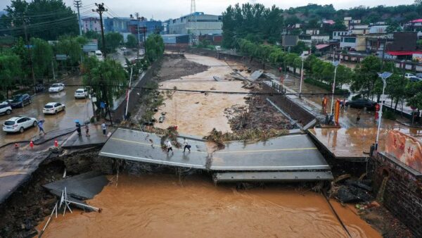
- More than a million people have been displaced and dozens killed due to flooding in northeastern China in July 2023, when remnants of Typhoon Doksuri hit the area, according to CNN. Flooding in the areas stranded residents, washed away bridges and highways, killing a total of thirty people in total. The storm brought the heaviest rainfall Beijing has experienced in 140 years, marking a significant test to the region.
- Flooding devastated homes for millions of people and killed at least 1,700 in Pakistan in November 2022, according to AP. At one point during these intense floods, nearly 1/3 of the country was underwater. A year later, the country has yet to recover fully. At the height of the crisis, nearly 8 million people were displaced. UNICEF estimates that roughly 20 million people still need humanitarian aid in flood-affected areas.
- In July 2021, more than 200 deaths in central Europe were blamed on the worst flooding there in decades, with more than six inches in less than 12 hours. For example, the German city of Reifferscheid received 8.1 inches of rain in just nine hours, as reported by CNN, in an area where the average rainfall for all of July is only 3.45 inches. AIR Worldwide estimates insured losses could approach $6 billion
There are several steps people, businesses, and organizations can take to prepare for flooding, including purchasing flood insurance, landscaping to improve drainage, turning off gas and electric services, and clearing debris from gutters, downspouts, sewers, and culverts (like city workers did as flooding developed in Bountiful, Utah, in early August 2021).
Ready.gov provides recommendations on what people should do before, during, and after a flood. In contrast, the Federal Emergency Management Agency provides a playbook with tabletop exercises for how organizations can prepare for a flood.
But you can only prepare for a flood if you know one is coming.
With the increasing threat of and vulnerability of society to flooding, several efforts are underway in both the public and private sectors to mitigate the impacts of flooding through better forecasts, preparation, and communication.
Preparing Against Flooding
As these floods become more prevalent, how can we prepare against flooding and mitigate the risk?
Flood risk mitigation involves reducing the risk posed to our communities, people, and property. We can do this through flood forecasting and improved operational workflows within businesses.
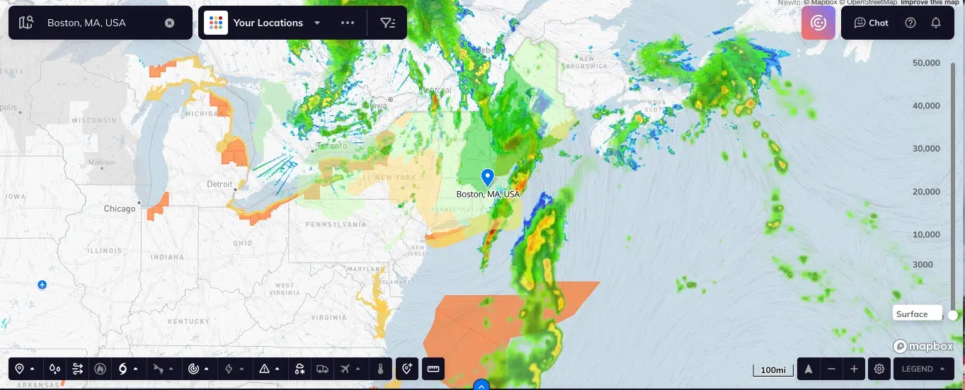
Emerging tools like those from Tomorrow.io can support flood risk mitigation by providing accurate and timely flood forecasts. People can use these forecasts to warn people of potential flooding and communicate alerts, so they can take steps to protect themselves and their property. Not only does Tomorrow.io provide forecasts for flood, they, more importantly, provide insights on when to act on those forecasts. By leveraging better forecasts, insights on when to act, and improved communication methods through early warning systems, we can work toward improving flood forecasting and mitigation.
How Can We Improve Flood Forecasting?
National Water Model
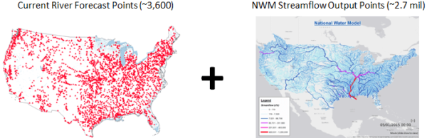
The National Oceanic and Atmospheric Administration’s National Water Model, which became operational in 2016, simulates observed and forecast streamflow over the entire continental United States. The model complements National Weather Service river forecasts at approximately 4,000 locations and expands water forecasts to 2.7 million streamflow locations where traditional river forecasts did not previously exist.
The model has demonstrated incremental improvements in flood forecasts, including the catastrophic flooding in Ellicott City, Maryland, 2018. Further improvements are expected when the next-generation National Water Model becomes operational, which is currently planned for 2024.
NOAA’s Precipitation Prediction Grand Challenge (PPGC)
In 2022, the world experienced 18 billion-dollar weather disasters totaling $165 billion. The costliest of these disasters being Hurricane Ian costing taxpayers roughly $112 billion to recover from.
Since 1980, the United States has sustained 341 weather and climate disasters, with overall damages reaching or exceeding $1 billion. 2023 is now the seventh consecutive year with ten or more billion-dollar weather and climate disasters in the United States — so far, we have seen 13 in 2023 alone.
NOAA’s Precipitation Prediction Grand Challenge (PPGC) recognizes that “a key to reducing these impacts is to be able to anticipate when, where and how much precipitation will fall” and notes that “although temperature forecasts have generally improved dramatically over the last few decades, precipitation forecasts (at all timescales) have not. “
Through an integrated research-to-operations effort, the PPGC aims to increase the rate of improvement in precipitation forecasts from 15% per decade to 30% per decade in five years and from 30 percent per decade to 50 percent per decade in 10 years. The PPGC will inform and support the activities of NOAA’s Earth Prediction Innovation Center (EPIC), a program established to advance weather modeling by facilitating a community-development approach and will also align with NOAA’s Artificial Intelligence Strategy and Cloud Strategy.
How is FEMA Changing Flood Insurance With Risk Rating 2.0?
Most residential and commercial property insurance policies don’t cover damage from flooding. Homeowners and businesses wanting to protect themselves from the financial risk of flooding must purchase a separate policy through insurance companies or agents. The vast majority of flood policies in the United States—more than five million—are provided through the National Flood Insurance Program (NFIP), which is managed by the Federal Emergency Management Agency (FEMA). NFIP rates are currently determined by an outdated methodology that results in “policyholders with lower-valued homes paying more than their share of the risk while policyholders with higher-valued homes are paying less than their share of the risk,” according to FEMA.
Starting in October, FEMA will introduce a new pricing methodology called Risk Rating 2.0, which FEMA calls “a transformational leap forward” to ensure rates are more fair and equitable. Risk Rating 2.0 will incorporate more factors into determining the cost of flood insurance for a given property—including flood frequency, multiple flood types (river overflow, storm surge, coastal erosion, and heavy rainfall), distance to a water source, property elevation, and the cost to rebuild—such that rates will more accurately reflect the flood risk specific to the insured property.
The Future of Flooding with Weather Intelligence

At Tomorrow.io, we are supporting or directly partnering with the above efforts to improve forecasts of and preparation for floods:
- Weather intelligence does far more than a typical weather forecast. It puts the forecast in context for your specific business or operations. Tomorrow.io’s Weather Intelligence Platform can monitor many locations at once for any combination of weather conditions that impact the operations of a business or organization. For example, a shipping and logistics company can get alerted when and where to reroute trucks due to predicted flooding. The platform can be tailored to drive decisive actions for virtually any industry.
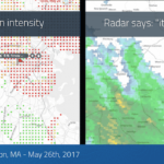
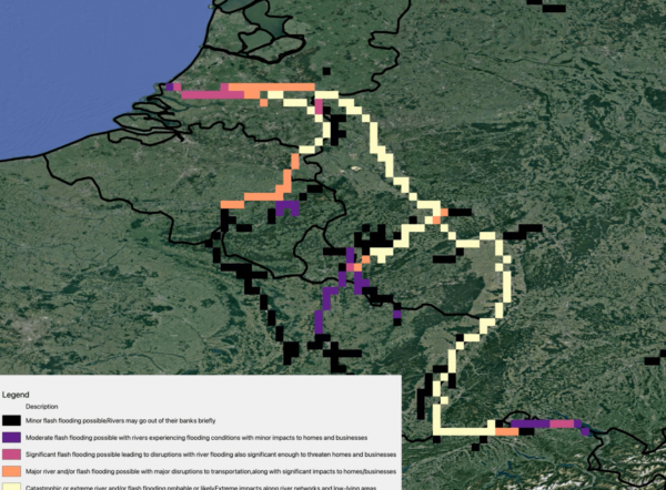
- Tomorrow.io has launched a new flood index to help businesses and organizations identify areas at risk for minor, moderate, significant, major, and catastrophic flooding up to five days in advance, even in areas without many hydrologic observations. The index, which accurately predicted flooding in Europe and China during a pre-launch verification analysis in 2021, is calculated using a mix of publicly available and proprietary hydrologic models, including NOAA’s National Water Model, as well as 40 years of historical analysis of runoff and streamflow.
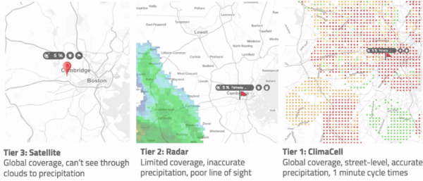
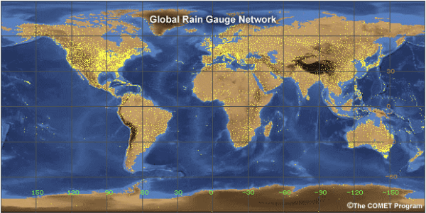
- To make our flood index and all of our forecasts and alerts even more accurate in the future, Tomorrow.io has successfully launched the world’s first commercially built weather-radar satellites. Tomorrow-R1 and Tomorrow-R2 are now orbiting 500 km above Earth in polar orbit carrying a Ka-band radar suited for detecting precipitation and critical ocean parameters. This successful launch marks the start of a constellation that will pave the way for groundbreaking advancements in global weather forecasting and flood forecasting. The operational constellation of approximately 20 satellites will, for the first time, provide global, high-resolution measurements of precipitation updated every hour, improving weather forecasts, especially for floods and hurricanes, and enabling reliable weather forecasts for the 5 billion people worldwide who currently live outside of traditional ground-based radar coverage.
There is much to be done to advance flood forecasting, and Tomorrow.io is at the forefront of the transformation by partnering with organizations like NOAA: The National Oceanic and Atmospheric Administration and NASA to bring better forecasting data to the world.
Need to better understand the risk of flooding?