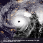
On August 29, 2021, Hurricane Ida barrelled into the Southeast United States with 150 mph winds, causing 115 deaths and over $65 billion in damages. From Louisiana up to New Jersey, heavy wind and more than 10 inches of rain in some states left cars, homes, and businesses underwater.
“We are in a whole new world now. Let’s be blunt about it. We saw a horrifying storm last night, unlike anything we have seen before. And this is a reality we have to face.” —NYC Mayor Bill De Blasio after the extreme flooding Sept. 1, 2021
Hurricane Ida’s extreme flooding — stretching up and down the East Coast — makes it the most destructive hurricane since Hurricane Katrina in 2005, and the costliest one since Hurricane Sandy in 2012.
Why was it so destructive? A lack of proactive communication around the flooding was behind much of the death and destruction. But it is possible to better predict extreme flooding and to better communicate the risks to the public.
How Extreme Floods Happen
Floods occur when water overflows, soaks, or submerges dry land. Heavy thunderstorms, tropical storms, tornadoes, hurricanes, or other extreme weather events can impact water levels and cause flooding. Rising tides and storm surges make coastal cities especially vulnerable to flooding.
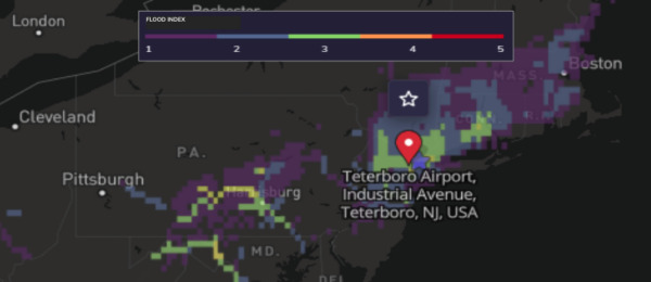
The Tomorrow.io Flood Index highlighted areas at risk for extreme flooding from the remnants of Hurricane Ida.
Extreme flooding events happen more and more often in the United States, partially because of the impact of climate change and partially because of the increased development of available land. Currently, one in ten American properties carries a significant risk of flooding. By 2025, that number is projected to grow by another 11%.
This is even more of an issue in urban areas, where rapid rain can easily overwhelm runoff and drainage systems. Since many cities connect their rainwater drainage and sewage systems, this quickly escalates into an unsavory public health issue.
Cities, businesses, and organizations must prepare for flooding before it begins, but many current systems don’t provide enough warning. During Hurricane Ida, the severity of extreme flooding, especially in the Northeast, took many people by surprise. The National Weather Service issued its first-ever flash flood emergency for New York City and the surrounding areas shortly before flooding overtook buildings, cars, and subway stations.
What if there was a better way to prepare individuals, cities, businesses, and organizations for the threat of flooding further in advance?
How to Predict Extreme Flooding Before It Happens
Determining the risk of flooding at any one location involves a complex combination of many factors, all of which are continuously monitored by Tomorrow.io’s Flood Risk Index.
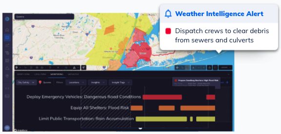
Weather alerts seen in the Tomorrow.io platform as the remnants of Hurricane Ida impacted the Northeast
Combining a mix of publicly available and proprietary hydrologic models with 40 years of historical analysis of runoff and streamflow, Tomorrow.io’s Flood Risk Index can identify the risk of river and urban flooding up to five days in advance.
The system scales risk from 1 (low) to 5 (catastrophic) and updates daily. This then feeds into our Weather and Climate Security Platform, which automates monitoring of multiple locations and sends alerts to assigned personnel based on location-specific criteria.
With Hurricane Ida, Tomorrow.io’s Flood Risk Index identified the risk of significant flooding in the Northeast 48 hours before the National Weather Service issued any flash flood warnings, accurately predicting extreme flooding across New York, New Jersey, and Pennsylvania for September 1 and 2.
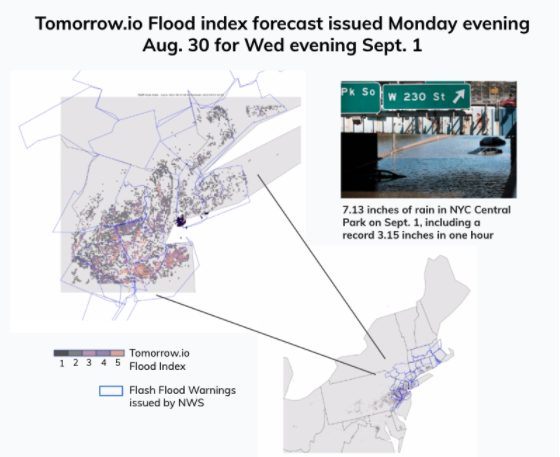
Tomorrow.io’s Flood Risk Index aligned well with Flash Flood Warnings ultimately issued by National Weather Service
“Our company is tackling this challenge from two different, but equally important angles. We are both improving the accuracy, detail, and timeliness of weather forecasts, and we are transforming how forecasts are translated into proactive actions that can save lives, reduce damage, improve operations, and limit financial loss.” —Shimon Elkabetz, CEO and Co-Founder of Tomorrow.io
Tomorrow.io Helps Cities, Businesses, and Organizations Prepare for Extreme Flooding
Don’t wait for the rain to start to prepare for the next extreme flooding event. Tomorrow.io’s Weather and Climate Security Platform gives you the historical and real-time updates you need to be able to plan for rain intensity, accumulation, or flood risk, so you can anticipate flooding before it happens — dispatching crews and sending customer or citywide alerts as needed.
