TL;DR:
- Tomorrow.io’s CSO unveiled advancements in early warning systems and weather prediction at ClimaCon4.
- Current radar coverage is limited, leaving vast gaps in global forecasting.
- Tomorrow.io is launching compact weather radar satellites to address this gap and provide full global coverage.
- Space-based radar systems allow for 3D imaging of storms, improving forecast accuracy and warning lead times.
- Tomorrow.io aims to launch up to 20 radar satellites in the next two years, revolutionizing storm observation worldwide.
ClimaCon4 was one for the books!
At our fourth annual ClimaCon conference, Tomorrow.io CSO Rei Goffer unveiled several major advancements that will revolutionize early warning systems and weather prediction globally.
In his opening, Goffer explained how Tomorrow.io is leveraging space-based radars along with advanced modeling and software to provide life-saving weather intelligence to countries and organizations managing climate risk.
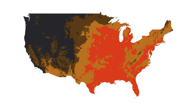
Vast Gaps Exist in Current Radar Coverage
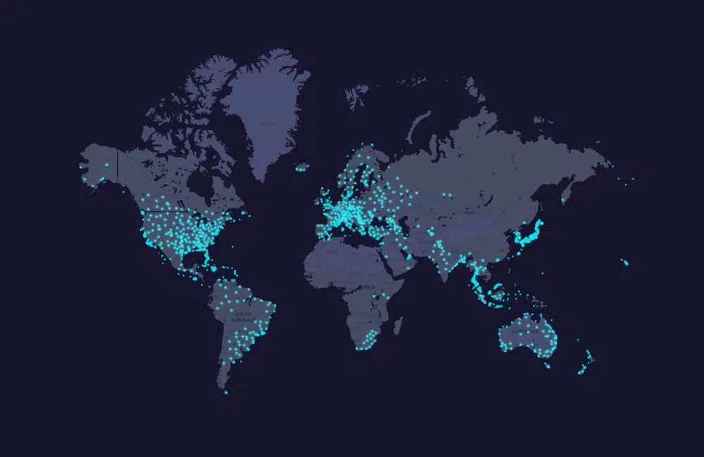
A major limitation of global forecasting is the extreme lack of global on-the-ground weather radar coverage.
Despite radar being a 50+ year old technology, these systems currently only cover about 5% of the Earth’s surface, mainly in wealthy nations. For example, very few operational radars exist across Africa, Latin America, and South Asia.
“Today, radars cover mostly rich countries. We have them in continental US, parts of Europe, Japan, Singapore, coastal Australia, and then really spread elsewhere. And that’s a shame because radars are perhaps the most important instrument we have to monitor the atmosphere.”
Goffer explained that this vast gap means scientists cannot accurately monitor storm development or predict floods in most at-risk regions.
Enter Space-Based Radar Systems
To address this weather gap, Tomorrow.io continues to innovate by launching compact weather radar satellites that can scan clouds from low Earth orbit (LEO). “We spent a lot of time thinking of how we can solve this problem because we saw the outputs of this problem coming over and over again…you can’t give a good enough precipitation forecast in Kenya or Ghana or in Brazil or in India.”
Goffer tells the audience that two prototype satellites have already been deployed in 2022, which were the first privately developed space-based weather observation systems ever built.
He explained that by reducing the size and cost compared to legacy government systems, Tomorrow.io can launch dozens more radars over the next 1-2 years. This will provide full global coverage and scan intervals of 60 minutes or less per satellite.
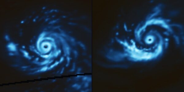
Seeing Inside Every Storm on Earth
The key benefit that space-based radar provides is the data needed to be able to see inside clouds and precipitation in 3D. Essentially providing an X-ray view of internal storm structure and intensity changes that no other current technology allows.
Goffer stated, “It’s like the difference between taking a photo of you and trying to tell you if your arm is broken versus giving you an x-ray. That’s what we’re doing with those satellites – we’re basically doing an x-ray and an MRI scan for every cloud on earth all the time.”
Early Results Show Great Promise
In initial testing, Tomorrow.io’s systems have already proven able to observe storm features like eyewall replacements 4x more frequently than even the most advanced government satellites combined. This level of detail is critical for seeing rapid strengthening or weakening.
The implications are profound according to Goffer — “We’re going to be able to do that for every storm, everywhere, not just the ones hitting the US or, you know, the Atlantic, but ninety percent of the storms are in the Pacific. We’re gonna be able to see those as well.”
Vastly Improving Forecasts and Warning Times
With constantly updated 3D radar mapping, numerical weather prediction models can ingest far more realistic storm data. This will lead to major forecast accuracy gains compared to current capabilities for heavy rain, flooding, hurricanes, and other high-impact events.
In addition, earlier awareness of intensifying threats translates directly into longer warning lead times for evacuation and emergency planning. Goffer highlighted how this will be revolutionary for early warning systems globally once fully deployed.
Launching a New Era in Weather Science
In closing, Tomorrow.io Co-Founder and CSO Rei Goffer commented that their radar satellite constellation fundamentally transforms storm observation worldwide. He invited the weather community to collaborate on new forecasting techniques and applications that harness this game-changing vision from space.
The lifesaving potential of global weather radar coverage is immense.
Over the next two years, Tomorrow.io aims to launch up to 20 compact radar satellites – ushering in a new era of predictive capability to keep vulnerable communities safe.
Learn more about Tomorrow.io AI and space enhancements with ClimaCon4 today.