Our Data Products
Browse our selection of foundational weather data products direct from our Pathfinder satellites, and request a sample dataset to evaluate operational integration today. These initial offerings pave the way for more advanced, high-refresh data coming soon.
Radar

GeoProfile
Level 1CCalibrated radar reflectivity profiles provide unmatched detail into precipitation systems, derived from fundamental reflectivity measurements as a function of radar range that capture backscatter from precipitation. Post-processing generates geolocated and calibrated data products optimized for advanced atmospheric analysis.
Read More

Precipitation
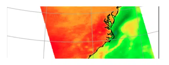
Level 2ATomorrow.io's L2A-PRECIP dataset provides estimates of hydrometeor water content, size, phase, and surface precipitation rate at the native sensor resolution, including probabilistic classifications for each profile: probability of surface precipitation, frozen precipitation, convective precipitation, and hail. This groundbreaking data enables enhanced accuracy in weather forecasting and climate adaptation.
Read More
Microwave Sounders

Brightness Temperature
Level 1BThe Level 1B-TB product provides geolocated antenna and brightness temperature measurements from the Tomorrow.io Microwave Sounder (TMS). These measurements, collected across 12 microwave spectral channels, offer critical insights into surface temperature, clouds, precipitation, water vapor, and atmospheric conditions. Available in near-real-time for immediate analysis, this data is essential for improving forecasts and understanding weather patterns through accurate, calibrated microwave observations, with final processing versions to follow.
Read More
Regridded Brightness Temperature
Level 1C-TCRThe Level 1C-TCR product provides regridded Level 1C data. This product is recommended for imagery and other applications that benefit from a uniformly spaced grid.
Read More

Intercalibrated Brightness Temperature
Level 1C-TCThe L1C-TC product converts the brightness temperatures from each TMS instrument to that of a reference TMS instrument (Tomorrow-S1). This is useful for applications that require a homogeneous data record from multiple satellites. The objective of L1C-TC is to remove the effect of differences in the spectral response function between the different TMS instruments.
Read More

Resampled Brightness Temperature
Level 1B-TBRL1B-TBR can be thought of as a lightweight alternative to L1B-TB. The primary differences are that the brightness temperatures have been resampled to the channel 11 geolocation. The use of a common geolocation removes the channel dimension from the geolocation and scan geometry variables in the L1B-TBR files. Thus, the file size is approximately 20% of the corresponding L1B-TB file.
Read More

Atmospheric Thermodynamic Vertical Profile
Level 2A-ATVPThe Level 2A-ATVP product provides atmospheric temperature and humidity profiles derived from Level 1C data. These profiles also include an estimate of uncertainty which depends on the complexity of the scene being observed, as well as some precipitation-related quantities such as ice water path and liquid water path.
Read More
Coming Soon
Sounder Data Products
Level 2B-HRPR
High Resolution Precipitation Rate
The Level 2B-HRPR product provides a high-resolution precipitation rate that is augmented by geostationary satellite imagery, where available, as well as a lower-resolution TMS-only precipitation product. Other precipitation-related quantities such as ice water path, liquid water path, and echo top will be added at a later date.
Level 2B-ETCI
Enhanced Tropical Cyclone Intensity
The Level 2B-ETCI product provides imagery of tropical cyclones and estimates of their intensity (maximum 10-meter wind speed and minimum sea level pressure).
Frequently Asked Questions
What format are your data products available in?
How can I access sample datasets?
How often are the datasets updated?
When will new data products be available?