 Precipitation
Summary
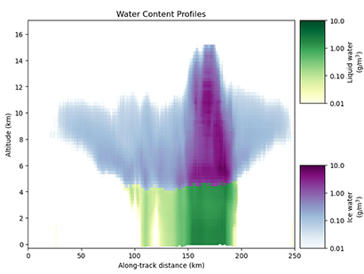
Level 2 products contain estimates of geophysical quantities retrieved at the native sensor sampling resolution (thus, the spatiotemporal dimensions are identical to the L1C-GEOPROF product). For a radar, these are typically the profile of hydrometeor water content, characteristic size, and phase (ice or liquid), as well as the surface precipitation rate and phase. In order to derive these parameters from the level 1C reflectivity profile, several intermediate steps are required, and outputs from these intermediate steps (e.g., echo classification, path-integrated attenuation) are also stored in the Level 2 dataset. The level 2 output also includes a probabilistic classification of each profile in 4 categories (probability of surface precipitation, probability of frozen precipitation, probability of convective precipitation, and probability of hail in the profile).
Product Information
The L2A-PRECIP datasets are stored as netCDF4 files. The samples provided contain a wide variety of precipitation systems spanning regions all over the world. An example “quicklook” plotting the retrieved profiles, surface precipitation rates, and classification is shown below with geostationary satellite imagery to provide context.
The retrieved precipitation rates have been validated for several overpasses over the United States against the Multi-Radar, Multi-Sensor (MRMS) gauge-adjusted radar-derived precipitation rates during August-November 2023. The overall correlation coefficient between the R1/R2-derived precipitation was 0.89, and the mean absolute percentage error was 38%, which is similar to or better than these statistics for the equivalent GPM KaPR-derived products over the same time period.
![]() tmrw-l2a-precip-profile-samples.zip
tmrw-l2a-precip-profile-samples.zip