 Brightness Temperature
Summary
The Level 1B-TB product from the Tomorrow.io Microwave Sounder (TMS) contains geolocated antenna temperatures and brightness temperatures, along with several other data fields related to the spacecraft status and instrument calibration.
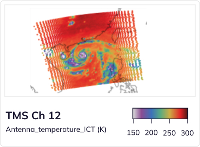
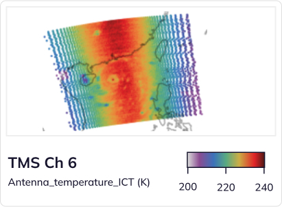
The antenna temperature is the fundamental measurement from the TMS instrument. It is a measure of the intensity of the radiation received by the TMS antenna in 12 microwave spectral bands, or channels, after being calibrated with a warm reference point and a cold reference point. Channel 1 is a window channel at 91 GHz, sensitive to surface temperature, clouds, precipitation, and water vapor; Channels 2-8 in the 114-122 GHz band sense temperature at progressively higher levels in the atmosphere; and channels 9-12 in the 183-204 GHz band sense water vapor and precipitation at progressively lower levels of the atmosphere. Because TMS has two warm calibration targets (noise diode–ND and internal calibration target–ICT), there are two sets of antenna temperatures corresponding to each of these calibration targets.
The brightness temperature is the antenna temperature modified to remove the impact of the portion of the antenna pattern that intercepts deep space or the spacecraft. In general this has the effect of increasing brightness temperatures at the scan edges (by removing the impact of cold space) and removing the effect of antenna sidelobe asymmetries. The provisional (V00-05) antenna pattern correction is based upon clear-sky differences between observations and simulations from co-located ERA5 data fields.
Product Information
The L1B-TB datasets are stored as netCDF4 files. The filename is the following format:
TMS[satellite number].1B-TB.V[major version]–[minor version].[stream].ST[start time of dataset].ET[end time of dataset].CT[creation time of dataset].nc
These come in two streams:
- Near-real-time (NRT): These files are generated as soon as TMS data is received at a ground station, and are separated into distinct granules that are separated by spacecraft maneuvers, transmit events, or other data gaps between valid science observations. A granule may be as little as 128 scans (about 4 minutes) or as long as 512 scans (20 minutes). Typically, around 100 NRT granules are produced each day per satellite.
- Final processing (not yet available): These files are separated into orbits that begin at each ascending equator crossing. These contain all data that was collected during the orbit, with flags for the various events (e.g., maneuvers, transmit events) that can affect science data quality. Typically, 15-16 orbits each day are produced for each satellite.
The current (V00-06) L1B-TB data product maturity is provisional. This is denoted by a major version number of 0. The geolocation and calibration have been assessed to be stable over 3+ weeks of observation, and an empirical antenna pattern correction and static bias correction has been applied to the brightness_temperature field. However, future refinement and modification of these fields is expected to occur over the next few months as additional and larger validation datasets are processed. Once accuracy requirements have been verified with these larger datasets, the product status will be considered validated (major version number >= 1).
![]() tmrw-tms-1B-TB-samples.zip
tmrw-tms-1B-TB-samples.zip