 Atmospheric Thermodynamic Vertical Profile

Summary
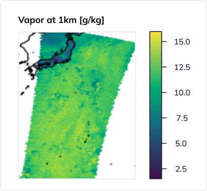
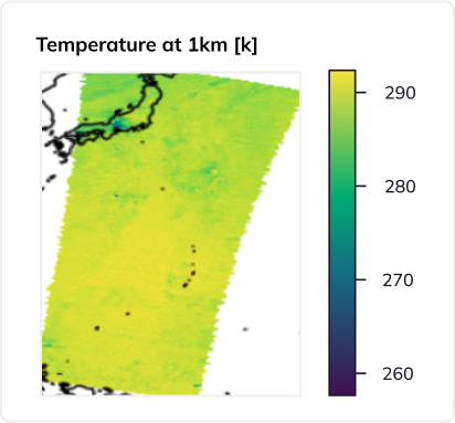
The Level 2A-ATVP product from the Tomorrow.io Microwave Sounder (TMS) contains profiles of temperature and water vapor as well as several integrated hydrometeor fields. L2A-ATVP utilizes a quantile regression neural network trained on high resolution global simulations and inference is performed on Level 1B-TBR resampled brightness temperatures.
Profiles of temperature and water vapor are provided on an equally spaced vertical grid up to 30 kilometers. This vertical structure is provided by the “sounding” channels in the TMS instrument that are sensitive to progressively higher levels in the atmosphere. Together, temperature and water vapor provide information about the thermodynamic structure of the environment and can be used to derive other quantities like relative humidity, dew point temperature, and dew point depression. Because TMS has channels sensitive to clouds and precipitation, the L2A-ATVP product also provides vertically integrated quantities of liquid and ice water (known colloquially as water paths).
The structure of the neural network implementation allows for calculation of the one-sigma standard deviation from the network’s output quantiles, providing uncertainties associated with each variable. Finally, since the L2A-ATVP product utilizes the resampled brightness temperature product (L1B-TBR) as an input, all variables in the files are retrieved on a common coordinate grid.
Product Information
The L2A-ATVP datasets are stored as netCDF4 files. The filename is of the following format:
TMS[satellite number].2A-ATVP.V[major version]–[minor version].[stream].ST[start time of dataset].ET[end time of dataset].CT[creation time of dataset].nc
These come in two streams:
- Near-real-time (NRT): These files are generated as soon as TMS data is received at a ground station, and are separated into distinct granules that are separated by spacecraft maneuvers, transmit events, or other data gaps between valid science observations. A granule may be as little as 128 scans (about 4 minutes) or as long as 512 scans (~20 minutes). Typically, around 100 NRT granules are produced each day per satellite.
- Final processing (not yet available): These files are separated into orbits that begin at each ascending equator crossing. These contain all data that was collected during the orbit, with flags for the various events (e.g., maneuvers, transmit events) that can affect science data quality. Typically, 15-16 orbits each day are produced for each satellite.
The current (V00-06) L2A-ATVP data product maturity is beta.


tmrw-tms-l2a-atvp-samples.zip