Global Microwave Observations & Hurricanes
The Defense Meteorological Satellite Program (DMSP) and the Special Sensor Microwave Imager/Sounder (SSMIS) have served the weather enterprise well over the past 15 years, improving weather forecasting and hurricane monitoring. As these satellites near the end of their extended service life – with some already experiencing performance degradation – the weather community is preparing for an expected transition with the DMSP program formally ending in September 2026. With data not yet available outside the DoD from the DMSP follow-on microwave mission — Weather System Follow‑on Microwave (WSF‑M) — there is a risk of increasing the length of gaps between observations, which can be as long as ten hours even before the loss of any of these satellites. While this change in availability of governmental microwave data was unanticipated, Tomorrow.io is ready to help with a growing fleet of microwave sounders ready to provide imagery this hurricane season.
Tomorrow.io’s Microwave Sounders (TMS)
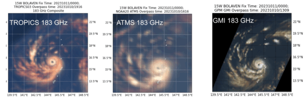
Figure 1: Microwave imagery (183 GHz) of Hurricane Bolaven from 2023 from 3 different sensors. (left) NASA’s TROPICS cubesat sounder which Tomorrow.io’s microwave sounder is based on. (middle) NOAA’s ATMS overpass (right), NASA’s GMI conical scanner.
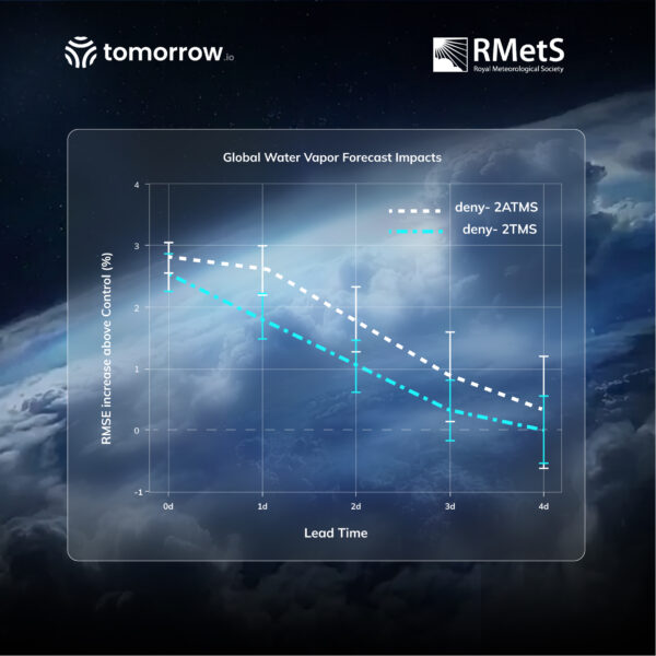
Tomorrow.io’s Microwave Sounder (TMS) satellites build directly on the NASA TROPICS heritage which have demonstrated hurricane imagery usefulness (Figure 1). Each 6U CubeSat carries a passive microwave radiometer with 12 channels across 91–204 GHz, a cross‑track scanning antenna, and a 2200 km swath, including key hurricane monitoring channels at 91 GHz and 183 GHz. Despite the much smaller satellite compared to the government-led missions (cereal box vs school bus), TMS delivers comparable horizontal resolution to SSMIS at the higher frequencies (~15 km). Not only does TMS pass the eye test (e.g., Figures 1-2), TMS data quality has been independently evaluated by the Joint Center for Satellite Data Assimilation (JCSDA), showing that TMS sounders significantly improved forecast accuracy for temperature, water vapor and wind across all atmospheric layers and geographical regions with traditional weather forecasting systems. Additional experiments presented at the ITSC‑25 conference and submitted to QJRMS for review show that Tomorrow.io’s sounders deliver 6‑hour forecast impacts comparable to much more expensive sounders, like ATMS for humidity, and AMSU-A for temperature.

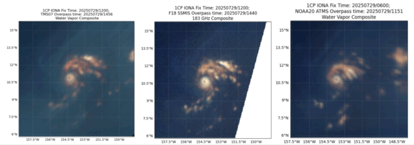
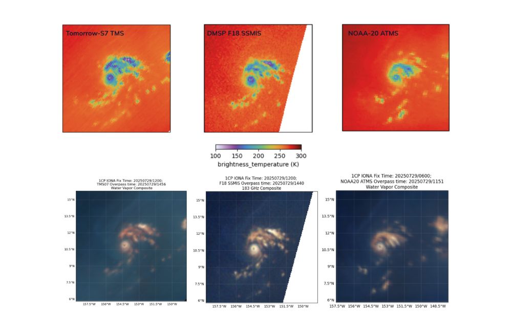
Figure 2: Tomorrow-S7 (left, TMS) and DMSP F18 (middle, SSMIS) observed Hurricane Iona at 1456 UTC and 1440 UTC, respectively, on 29 July 2025, a few hours after a NOAA-20 (right, ATMS) observation at 1151 UTC. In the top row, similar 183 GHz channels from all 3 instruments are shown here to demonstrate the similarity in data quality and resolution, and in the bottom row, multi-channel composites reveal similar storm and water vapor features across all three instruments.
As a direct comparison of TMS to DMSP SSMIS and NOAA ATMS, the above image shows the 183 GHz brightness temperature images and the same water vapor composite from Figure 1. On 29 July 2025, there was a near coincidental overpass of TMS-7 at the time of F18 (only 15 mins apart) for hurricane Iona south of the Hawaiian islands. Overall, TMS shows a very similar structure and values for Hurricane Iona compared to both SSMIS and ATMS.
A Constellation of Sounders
Figure 3: TMS microwave constellation composite imagery (from our 7 satellites on orbit) from early June 2025 in 6-hourly intervals
The current global microwave fleet, including the 3 aging DMSP satellites, often has 3-6 hour gaps in imagery of hurricanes. This large gap in observations leads to uncertainty in monitoring and forecasting hurricane intensity. The novel aspect of Tomorrow.io’s satellites is not just the sounders themselves, but the constellation they form. Since the first TMS launch in August 2024, Tomorrow.io has launched 7 sounders into various orbits that currently lead to 70% coverage globally over a 3-hour period, similar to government-owned sensors. Together, the combined coverage exceeds 90%, demonstrating the gap-filling capability of the Tomorrow.io constellation even before full capacity is reached. As additional satellites are launched through the end of 2025 and 2026, Tomorrow.io’s sounder constellation will enable sub‑hourly, multi‑channel microwave observations globally, closing the observation gap of hurricanes. An example of Tomorrow.io’s current constellation capability is shown in Figure 3.
Figure 4: TMS microwave constellation composite imagery of Hurricane Erick in June 2025
The example above highlights TMS’s rapidly updating scans of Hurricane Erick, including several overpasses within a few hours of each other.
NOAA + Tomorrow.io Partnership
These observations aren’t just theoretical – Tomorrow.io has already been working with NOAA as part of the Commercial Weather Data Pilot program. Under this program, Tomorrow.io has been providing NOAA with data from two TMS satellites since February 2025, while NOAA personnel have been providing independent evaluations of data quality and integrating the data into their products and real-time data systems.
Through this collaboration with NOAA and its cooperative institutes, scientists have already been experimenting with the TMS data for hurricane monitoring and forecasting. Derrick Herndon, a researcher for the Cooperative Institute for Meteorological Satellite Studies located at the University of Wisconsin–Madison, leads a team that develops AI techniques for estimating tropical cyclone intensity from satellite imagery.
“TMS intensity estimates are solid and help fill [microwave data] gaps, which is especially important as TROPICS nears the end of its mission.” Herndon said, also noting that TMS data were the only microwave observations of recent Hurricane Iona in a 10 hour gap between other sensors. This data that is shared with NOAA is available publicly at https://tropic.ssec.wisc.edu/real-time/DMINT/
Tomorrow.io doesn’t pretend that a limited constellation of small satellites can instantly replicate the raw horsepower of a bus‑sized SSMIS sensor. However, scalability and revisit rate matter as much as per‑pass resolution. By deploying a constellation of microwave sounders, Tomorrow.io can provide more frequent glimpses into storms, reducing latency in detecting rapid intensification and closing any potentially widening microwave data gaps globally. Tomorrow.io looks forward to continuing to work alongside NOAA, NASA, the Department of Defense and the broader meteorological community to help reduce humanity’s exposure to extreme weather.
(TL;DR)
Tomorrow.io is aiming to fill a critical data gap of microwave observations globally. There are currently 7 Tomorrow.io microwave sounders on orbit providing low latency (30-40 mins) data daily. Data from these sounders has already been shared with NOAA, and is being evaluated for use in weather forecasting tasks, including hurricanes.
Behind the Sensors: Expert Forecast | Episode 3
Go behind the scenes with atmospheric data scientists Dr. Joe Munchak and Dr. Randy Chase in Expert Forecast | Episode 3 as they unpack how microwave sounders sharpen storm analysis and strengthen operational resilience.
—————-
As the demands of modern forecasting grow, Tomorrow.io is committed to delivering the high-frequency, high-impact data needed to stay ahead of extreme weather.
Interested in evaluating our microwave sounder data for yourself?
Request a sample and see how Tomorrow.io’s satellite capabilities can support your forecasting efforts: https://www.tomorrow.io/satellite-data/data-catalog/