NASA’s Commercial Satellite Data Acquisition (CSDA) Program independently evaluated Ka-band precipitation radar data from Tomorrow.io’s pathfinder satellites Tomorrow-R1 and Tomorrow-R2, recommending it for scientific use.
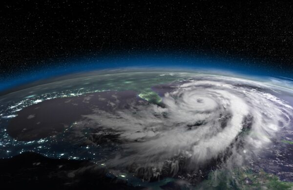
For decades, our understanding of global precipitation has relied on a small number of government-operated satellite missions — remarkable instruments, but limited in how often they can observe the same location and how much of the globe they can cover at any given time. As the climate shifts and extreme weather events intensify, the scientific and operational communities have been clear: we need more observations, from more vantage points, more often.
NASA’s Commercial Satellite Data Acquisition (CSDA) Program was designed to address exactly this challenge by identifying, rigorously evaluating, and making available high-quality commercial Earth observation data that can augment and complement the existing suite of public-sector instruments.
In a newly published quality assessment report, CSDA subject matter experts completed an independent evaluation of Ka-band precipitation radar data acquired from Tomorrow.io’s two pathfinder satellites, Tomorrow-R1 and Tomorrow-R2. The findings validate what is, to date, one of the most technically ambitious contributions to the CSDA program: a commercially built spaceborne precipitation radar system that meets NASA’s standards for scientific use.
What NASA’s Experts Found
The evaluation was comprehensive. NASA’s SME team assessed the data across multiple dimensions — product documentation, metrology, calibration, retrieval algorithms, precipitation accuracy, and geolocation — using a structured assessment framework based on the ESA-NASA Joint EO Mission Quality Assessment Framework guidelines.
The results were strong across the board:
Documentation and engineering rigor: Product information, user documentation, uncertainty characterization, sensor calibration algorithms, and retrieval algorithms all received grades of “Excellent” or “Ideal” — the highest marks in NASA’s assessment framework. NASA’s evaluators specifically noted that the vendor’s documentation was “similar in content and format to NASA documentation,” an indication of the engineering discipline applied to the instrument design, calibration, and data processing pipeline.
Calibration integrity: Surface return analysis showed the commercial radars’ normalized radar cross sections fell within 0.5 dB of NASA’s own Global Precipitation Measurement (GPM) Mission Ka-band radar — suggesting the commercially built instruments achieved calibration consistency with a flagship NASA mission instrument. The evaluation further noted mean calibration biases of just −0.4 dB and less than 0.1 dB for the two radars, respectively, confirming the precision of the pre-launch and in-orbit calibration procedures.
Precipitation detection: Both radars demonstrated strong skill in distinguishing between precipitation and no-precipitation events over the continental United States, with a probability of detection around 0.82 and a critical success index around 0.76 when validated against the NOAA/NSSL Multi-Radar/Multi-Sensor (MRMS) ground reference network — a widely recognized benchmark for U.S. precipitation validation. This detection performance is underpinned by the radars’ improved sensitivity: with a minimum detectable signal of approximately 8 dBZ (roughly 0.1 mm/hr), the Tomorrow.io instruments can detect lighter precipitation than the GPM Ka-band radar’s commonly referenced threshold of approximately 12 dBZ (roughly 0.2 mm/hr).
Precipitation quantification: The radars showed strong performance in representing precipitation across intensity categories — light, intermediate, and heavy. One of the two instruments achieved a correlation of 0.93 with ground-based measurements, and both satisfied the GPM mission’s science requirements for precipitation bias at a resolution ten times finer than what GPM targets (5 km vs. 50 km). Random errors partially satisfied the GPM requirements at this finer resolution, a notable result given that the science requirements were designed for a much coarser spatial scale.
Geolocation accuracy: Surface height estimates from the radar data correlated at 0.98 with an independent digital elevation model, confirming the data is accurately geolocated to within a few hundred meters — well within the accuracy requirements for the system’s intended applications.
Based on these findings, the evaluation team recommended that the precipitation radar data be considered for NASA scientific use, contingent on alignment with specific science objectives and application needs.

NASA’s CSDA program identifies, evaluates, and acquires commercial remote sensing data that enhances NASA’s Earth science research and applications — independent assessment before data enters scientific use.
A Commercially Built Instrument That Meets NASA Standards
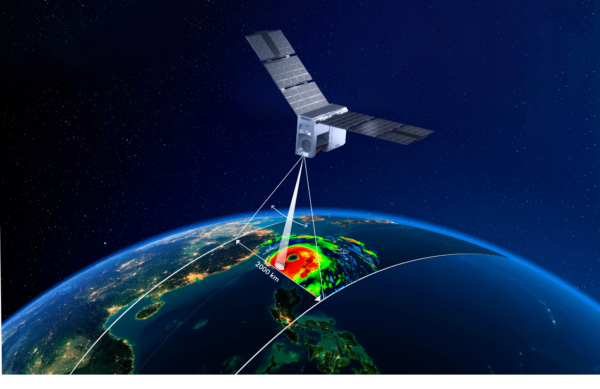
The technical details are worth underscoring. The Tomorrow.io radars are all-solid-state Ka-band (35.5–36 GHz) instruments with 1.2-meter solid Cassegrain reflector antennas, launched into approximately 550 km altitude sun-synchronous orbits. They deliver 4.5 km horizontal resolution and 250-meter vertical resolution — specifications that required the kind of precision engineering and calibration rigor historically associated with government-funded missions.
That a commercially designed and built spaceborne radar can produce data consistently calibrated within 0.5 dB of NASA’s GPM Ka-band radar, earns “Ideal” ratings for its retrieval algorithms and uncertainty characterization, and satisfies GPM science requirements for precipitation bias at ten times finer resolution is a meaningful technical achievement. It demonstrates that the commercial space sector has developed the capability to build instruments that meet the quality bar the scientific community requires.
Why This Matters for the Research Community
The implications extend well beyond a single vendor evaluation. The CSDA program’s work here establishes a precedent and a pathway: commercial precipitation radar data, when held to NASA’s standards and independently validated by the agency’s own subject matter experts, can meet the quality bar required for scientific research and applications.
For the research community, this opens new possibilities across multiple domains:
Weather forecasting: Additional spaceborne precipitation observations provide new inputs for numerical weather prediction models and data assimilation systems, particularly over oceanic and remote regions where ground-based radar coverage is sparse or nonexistent. For national and international meteorological services — many of which lack comprehensive ground-based radar networks — space-based precipitation data validated to this standard represents a new resource for improving forecast accuracy and lead times.
Risk modeling: Insurance and reinsurance firms, infrastructure planners, and emergency management researchers gain access to precipitation observations that can improve the statistical characterization of extreme rainfall events. Validated spaceborne radar data at 4.5 km resolution offers the granularity these applications demand.
Climate trend analysis: A growing archive of spaceborne precipitation radar data creates new opportunities to study long-term precipitation patterns, validate reanalysis products, and improve our historical understanding of how precipitation regimes are shifting — an important metric for climate adaptation planning and policy.
Flood and flash flood research: The 4.5 km horizontal and 250-meter vertical resolution of the evaluated radar data provide the kind of granularity that hydrological researchers need to study the precipitation signatures associated with flash flood events — complementing existing ground-based networks, especially in the vast areas of the world they do not cover.
Convective storm science: Ka-band precipitation radar observations from low Earth orbit offer a different perspective on convective systems than what ground-based radars provide, enabling researchers to study storm structure and precipitation processes from above — valuable for improving severe weather warnings and understanding how convective patterns are evolving.
Applications Beyond the Research Lab
While the CSDA evaluation focused on scientific quality, the validated performance of this data has implications well beyond the research community. Industries that depend on accurate precipitation intelligence stand to benefit as well:
Aviation: Precipitation is among the leading causes of flight delays, diversions, and safety incidents. Spaceborne radar data that can detect and quantify precipitation over oceans and remote regions — where ground-based radar does not exist — fills a critical gap for oceanic route planning, turbulence avoidance, and terminal area operations worldwide.
Insurance: The (re)insurance industry’s ability to price risk depends on accurate precipitation records. NASA-validated radar data at high resolution creates a new, independent source for catastrophe model calibration, loss attribution, and the development of parametric insurance products tied to verified precipitation triggers.
Agriculture: From planting decisions to harvest timing to irrigation management, agriculture depends on precipitation data. For the world’s major agricultural regions — many of which have little or no ground-based radar coverage — a validated spaceborne radar dataset offers a new foundation for precision agriculture, crop yield modeling, and drought monitoring.
Supply chain: Global supply chains are increasingly exposed to weather-driven disruptions across ports, transportation corridors, and production facilities. Precipitation radar data with global coverage enables logistics and supply chain operators to anticipate disruptions earlier and route around weather-impacted areas with greater confidence.
Worldwide meteorological services: Many national meteorological and hydrological services, particularly in developing nations, operate with limited or no ground-based radar infrastructure. Precipitation data validated against NASA’s quality standards — and available globally — represents a step change in the observational resources available to these agencies for public safety, water resource management, and agricultural planning.
The CSDA Model: Augmentation, Not Replacement
What CSDA provides is a structured mechanism for the scientific and applications communities to benefit from the rapid innovation happening in the commercial space sector. As the program’s own documentation states, its objective is to “identify, evaluate, and acquire commercial remote sensing data that enhances NASA’s Earth science research and applications” and to provide “a cost-effective means to augment and/or complement the suite of Earth observations acquired by NASA and other U.S. government agencies and those by international partners and agencies.”
Since its establishment in 2020, CSDA has conducted multiple on-ramp activities, bringing several commercial data vendors into its evaluation pipeline. The program’s SME-led assessment framework — which provides valuable feedback to private-sector providers, fostering “innovation, improved data products, and alignment of industry capabilities with NASA’s evolving scientific needs” — ensures that data quality is evaluated independently and transparently before any data is made available for research use.
What Comes Next
The validated data evaluated in this report represents a subset — observations from two pathfinder satellites over the continental United States, with Tomorrow-R1 providing approximately two months of data and Tomorrow-R2 contributing a three-week evaluation period. The full constellation vision would provide significantly broader global coverage and temporal frequency, creating an observation infrastructure that complements GPM and extends the precipitation measurement record.
For universities, government laboratories, meteorological services, and research institutions, the CSDA program’s evaluation creates a clear signal: this data has been independently assessed against NASA’s quality standards, and it meets the threshold for scientific consideration. Researchers interested in accessing validated commercial precipitation radar data through the CSDA program can learn more at the CSDA Program website: https://science.nasa.gov/earth-science/csda/
The science of precipitation measurement has always advanced when new observation capabilities became available — from the Tropical Rainfall Measuring Mission to the Global Precipitation Measurement mission. NASA’s CSDA program is ensuring that the next chapter of that story includes the best data the commercial sector has to offer, built to the standards the scientific community expects, and validated by the agency the world trusts to get it right.
Sources
- NASA / CSDA Program, Quality Assessment Report: Ka-band Precipitation Radar Data from Tomorrow.io (Tomorrow-R1 and Tomorrow-R2).
- ESA-NASA Joint EO Mission Quality Assessment Framework — evaluation methodology applied by CSDA subject matter experts.
- NASA Global Precipitation Measurement (GPM) Core Observatory — calibration and science requirements used as the reference standard.
- NOAA / NSSL Multi-Radar/Multi-Sensor (MRMS) System — ground reference network used for U.S. precipitation validation.
- NASA CSDA Program overview — science.nasa.gov/earth-science/csda/
▽