TL;DR
- AI models trained on decades of atmospheric data are revolutionizing forecasting, running accurate simulations in minutes instead of hours.
- Tomorrow.io’s shoebox-sized satellites deliver high-quality microwave sounder data comparable to legacy government systems at a fraction of the cost.
- Hourly refresh rates capture fast-changing storms, filling observational gaps left by aging systems.
- Microwave imagery reveals storm intensity and structure hidden beneath cloud tops, critical for resilience.
- Tomorrow.io’s end-to-end stack, from satellites to AI to decision platforms, provides hyperlocal, actionable forecasts businesses and communities can trust.
- This episode features Randy Chase, Tomorrow.io’s Atmospheric Data Scientist, breaking down how AI and satellite innovation are reshaping the future of weather intelligence.
Opening Paragraph
Weather forecasting is entering a new era. For decades, forecasts relied on physics-based models running on expensive supercomputers. Now, artificial intelligence and satellite innovation are rewriting the rules. In this Expert Forecast, Tomorrow.io’s Randy Chase explains how combining AI-driven models with Tomorrow.io’s microwave sounder constellation is making forecasts faster, more localized, and more actionable, just as legacy government satellites approach end-of-life.
AI Forecasting: A New Paradigm
Traditionally, forecasting required solving complex equations of fluid dynamics on massive supercomputers. These simulations could take hours to run, often delaying updates.
AI models change the equation. By “watching” decades of reanalysis data like ERA5, they learn how weather evolves without crunching every equation. The result is forecasts that run in minutes on a laptop or GPU.
Randy explains that Tomorrow.io is leveraging this paradigm to deliver hyperlocal forecasts, updating as often as every 15 minutes at resolutions of around 3 kilometers, perfect for operational decisions like rerouting trucks around hailstorms or deciding whether to delay a flight.
Shoebox Satellites vs. School Bus Systems
Legacy microwave sounders historically flew on large, expensive government satellites, each costing hundreds of millions of dollars. These sensors have been essential for hurricane monitoring and precipitation detection, but many are now aging or degrading.
Tomorrow.io has miniaturized that capability into satellites the size of stacked laptops. Despite their size, they provide high-quality microwave data validated by independent agencies, ensuring they can plug seamlessly into both AI and physics models.
The smaller size cuts costs and enables constellation deployment, offering broader global coverage at higher refresh rates.
Why Refresh Rate Beats Resolution
When it comes to forecasting storm intensity, timing matters more than detail. Traditional satellites might only pass over a storm every 3 to 10 hours, far too slow to capture sudden intensification or collapse.
Tomorrow.io’s constellation is designed for hourly or better refreshes worldwide. That cadence, combined with AI-powered assimilation pipelines, allows forecasts to:
- Track hurricanes through rapid intensification phases
- Spot thunderstorms most likely to produce hail or lightning
- Support industries with real-time operational insights
As Randy puts it, “If your image is 10 hours old, it doesn’t matter how sharp it is, you have already missed the moment.”
Inside the Storm: What Microwave Data Reveals
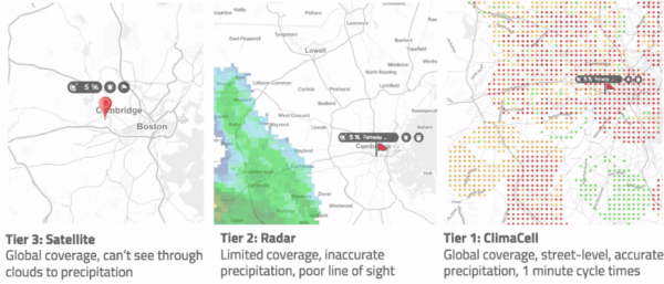
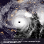
Unlike visible imagery, which only shows cloud tops, microwave sounders penetrate the storm to reveal precipitation rates, ice scattering, and humidity profiles.
That is critical for:
- Hurricane forecasting, where eyewall structure signals future intensity
- Maritime operations, where radars cannot reach
- Localized resilience, such as knowing which thunderstorm cell will drop hail on a specific shipping route
With Tomorrow.io’s system, users from global supply chains to local commuters get more than just a “rain or shine” forecast. They get the detail and timing needed to act.
Building Tomorrow: From Satellites to Actionable Forecasts
Tomorrow.io is not just building satellites; it is building an end-to-end forecasting pipeline:
- Collect: Hourly microwave data from proprietary satellites
- Assimilate: Feed it into fast, AI-enabled models that handle massive datasets
- Deliver: Translate results into actionable alerts through dashboards and APIs
And the company is opening the door for the community. Through the Build Tomorrow initiative, the first Hurricane Intensity Challenge gives students, developers, and researchers access to simulated microwave hurricane datasets to experiment with intensity forecasting, helping shape the future of resilience.
Conclusion
This Expert Forecast highlights how AI forecasting and satellite innovation are converging to transform weather intelligence. By combining rapid, high-quality microwave data with fast-learning AI models, Tomorrow.io is delivering the kind of timely hyperlocal forecasts that legacy systems could never achieve.
This is not just about better forecasts; it is about building resilience for industries, communities, and individuals worldwide.
FAQ
What is AI weather forecasting?
AI weather forecasting uses machine learning models trained on decades of atmospheric data to predict weather patterns. Unlike traditional physics-based models that run slowly on supercomputers, AI forecasts can generate accurate predictions in minutes. Tomorrow.io applies AI to deliver hyperlocal forecasts that update as often as every 15 minutes.
How are Tomorrow.io’s satellites different from traditional weather satellites?
Traditional microwave sounders fly on large, expensive government satellites. Tomorrow.io has miniaturized this technology into shoebox-sized satellites that provide the same high-quality data at lower cost. This makes it possible to launch constellations that refresh observations hourly instead of every 3 to 10 hours.
Why is the refresh rate important for weather forecasting?
Refresh rate determines how often satellites capture new data. Legacy systems may only provide updates a few times per day, which can miss rapid storm intensification. Tomorrow.io’s constellation delivers hourly microwave observations, giving forecasters near real-time insights for hurricanes, thunderstorms, and other fast-changing weather events.
Can small satellites provide reliable weather data?
Yes. Independent evaluations have confirmed that Tomorrow.io’s satellites produce high-quality microwave data that integrates seamlessly with both physics-based and AI weather models. This allows small satellites to match or exceed the performance of legacy instruments.
What type of data do Tomorrow.io’s satellites provide?
Tomorrow.io’s microwave sounders penetrate cloud cover to measure precipitation, water vapor, ice, and humidity inside storms. This provides a more complete picture of storm structure and intensity than visible or infrared imagery alone.
How does Tomorrow.io help communities and businesses build weather resilience?
By combining hourly satellite data, AI-powered models, and an end-to-end forecasting platform, Tomorrow.io gives businesses and governments actionable insights. This helps shipping companies avoid dangerous storms, airlines reduce delays, utilities pre-position crews, and communities prepare sooner for severe weather.
Who can access Tomorrow.io satellite data?
Tomorrow.io partners with agencies like NOAA and offers satellite data and forecasts through its weather intelligence platform and APIs. The public can also access some datasets with a delay, and developers can participate in open initiatives such as the Build Tomorrow Hurricane Intensity Challenge.
