This post originally appeared on Tomorrow.io.org.
In the coming months, the global climate will be directly impacted by La Niña, the opposite of the El Niño circulation.
La Niña can significantly alter seasonal climate conditions such as temperature and rainfall patterns. These changes can lead to a wide range of impacts—both good and bad—on agricultural production, water availability, disease outbreaks, fishery catches, and much more.
This weather pattern will have a major impact on communities across Africa, including a higher chance of both flooding and drought, depending on the location.
Here’s what you need to know about La Niña, the upcoming forecast, and the impact on African communities.
What is La Niña?
We keep hearing about “La Niña”, but what does this actually mean?
La Nina is a large-scale pattern of colder than normal water in the equatorial Pacific. It varies from year to year, but La Niña has an impact on weather around the world.
La Niña typically increases the likelihood of both above-average and below-average rainfall in certain areas in Africa. Studies show that La Niña is likely to have the most severe impact on south-central Somalia, southern Ethiopia, northwestern and eastern Kenya, and northeastern Tanzania.
These conditions would negatively affect crops harvested in February and March, worsen livestock body conditions, and trigger increased livestock migration, which facilitates the spread of livestock diseases.
The Past 6 Months in Weather
The past 6 months have seen opposing weather trends for different parts of Africa.
Sudan, South Sudan, West Ethiopia, and the Northern parts of Uganda, all experienced a wetter-than-average period (especially July-September), up to 200% with respect to precipitation amounts. The outcome was severe flooding of the Nile River in early September.
The flooding in countries like South Sudan and Sudan were the worst we’ve seen in decades. The high water level and flooding resulted in hundreds of casualties, caused damage to agriculture and property, and displaced hundreds of thousands of people from their homes. Wetter than average conditions were reported also in the Southern parts of Chad, Nigur, Aali, and Mauritania associated with flash floods and river flooding.
On the other hand, the Northern parts of the Democratic Republic of Congo and areas along the Gulf of Guinea experienced less precipitation than usual, in comparison.
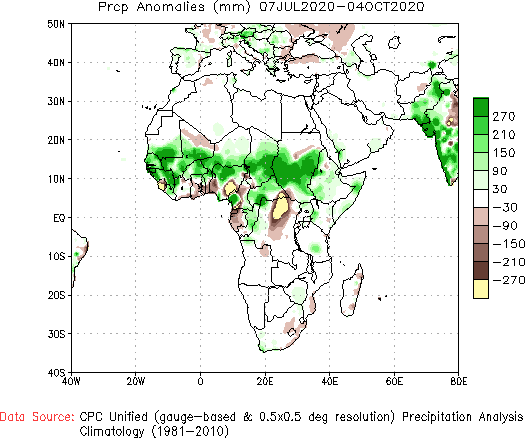
Figure 1: Precipitation anomaly for the period July-September 2020 in respect to the 198102020 climatology. Data source: Climate prediction center, NCEP.
The La Niña Forecast for Africa
Based on global models, the Tomorrow.io forecast for the coming months of October to December in Africa shows the following:
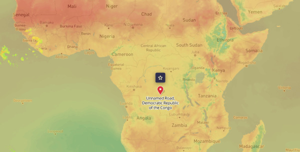
Below-average precipitation in the Southern parts of Sudan and the Northern parts of South Sudan. Dry to much dryer than average in Kenya (mostly Eastern Kenya), Ethiopia, Eritrea, and Degabuti, meaning that the horn of Africa is going to face drought conditions.
Drier than average conditions are on the way also to part of West Africa, especially through November and December in Guinea, Sierra Leone, Liberia, Togo and the coastal areas of Nigeria. Down South, Angola and Namibia are also going to face dry conditions in the coming two months.
On the other hand, most of Tanzania, Zambia and the Southern parts of the Democratic Republic of Congo are going to see wetter than average conditions with increasing flood threats.
What Does This Mean For You?
How are you preparing for La Nina? What does it mean for you? We want to hear from you and share your stories. You can reach out directly or at TomorrowNow.org.
Farmers are likely to be most severely impacted by this phenomenon as well as the agricultural services and supply chains they depend for market access and agricultural inputs. For regions at risk of drought, water availability will need to be managed carefully and food production will likely be impacted. Areas at risk of heavy rains, flooding or extremely hot or cold weather will likely see more animal disease outbreaks as well as plant pests and forest fires.
But there are ways to build resilience and prepare in advance and pivot during an expected weather event. For those with access to frequently updated localized forecasts, a farmer will know in advance when rains are coming, when there will be dry spells, and when a storm is about to hit. They will track the weather daily as it evolves, and prepare and adapt accordingly. Emergency responders will also pay close attention to the at risk regions to ensure they are prepared best they can be, and in the case of an emergency, they will be ready to provide assistance.
Unfortunately, localized daily weather forecasts are inaccessible to 5 billion people globally today. This is the global weather gap we are on a mission to close through Tomorrow.io.org
