Tomorrow.io’s Pathfinder radar satellites are proving the value of spaceborne Ka-band radar with every orbit and observation collected. They’ve already been used to demonstrate the accuracy of of rainfall observation (on par with ground radar systems) and the advantage of global coverage, for example, to monitor hurricanes and other storms that form over the ocean, far from ground radar networks. Now, Tomorrow-R1 has captured a prototypical thunderstorm off the coast of Australia in exquisite detail, showcasing the capability of spaceborne Ka-band radar to detect and monitor severe weather events.
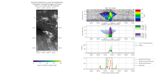
This 4-panel visualization shows the thunderstorm captured in Tomorrow.io’s satellite data, with each level revealing further internal storm details – from the raw radar reflectivity measurement to derived products like hail probability and rain rate/type.
Synopsis:
- The detailed imagery captured by our satellites closely mirrors the characteristics described in meteorological textbooks, providing a real-world example of a prototypical squall line.
- This observation highlights our capability to monitor and analyze severe weather phenomena over regions where ground-based radar coverage is currently sparse or non-existent.
- The precision and clarity of the data obtained from this storm capture can be ingested into our predictive models, leading to significant improvements in the accuracy of weather forecasts.
Operational Insights from the Thunderstorm Observation
The observation of the single-cell thunderstorm off the coast of Australia provided several operational insights that have implications for future meteorological research and forecasting:
- Storm Structure and Dynamics: The satellite imagery revealed the internal structure of the thunderstorm in unprecedented detail, including the anvil-shaped structure with overshooting tops indicative of strong updrafts and severe turbulence;
- Precipitation Patterns: The data allowed scientists to observe and analyze the precipitation patterns within the storm, with the clear transition from ice to liquid as precipitation falls and the strong echoes associated with large ice particles (graupel and hail) aloft;
- Temperature and Humidity Profiles: Together with data from Tomorrow.io’s microwave sounders, which will launch starting later this year, researchers can infer temperature and humidity profiles within the storm, providing valuable information for understanding the conditions that lead to severe weather events.
Future Directions in Satellite Meteorology
The successful observation of this thunderstorm marks just the beginning of what is possible with Tomorrow.io’s Pathfinder satellites. This single thunderstorm observation highlights the immense potential to achieve new scientific breakthroughs, significant forecast accuracy improvements, and enhanced public safety outcomes. Interested in learning more? Explore our space mission and Pathfinders, specifically.
